Today we critiqued our installations based on our Alfred systems research. Our group thought we played it a little safe with our installation. So, we were challenged to push boundaries and rework our piece in 20 min. The full result is linked below.
Author: gmdunham
Alfred Systems: Group

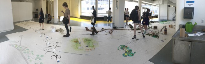
Reflection: Our group met twice, once on Friday to discuss our plan for the visual and once on Saturday to put everything together. On Friday we each described what we did for our personal research and how everything could come together as a whole. Most of our group members had 2-D elements like pictures and posters, so we decided to collect a few more 3-D elements. It was nice to bounce ideas off of other people. I was not sure how I wanted to display the water samples I collected, but after discussing it with the group we decided to combine some found water bottles, from consumption, cut them up and use them to hold the water. They were clear so you could clearly see the difference in water samples.
On Saturday we met early, around 8:30 AM, and started to play with the materials we had collected. The posters from activity/community were arranged into a large circle and the footprints were placed to look like a winding path upwards. Originally we were going to hang the water bottles, but the plastic strips we used for string could not hold that amount of weight. Instead we used pins to secure the bottle directly to the wall. we then hung strings with wrappers from the bottles to represent consumption.

1st

2nd
Story of the Week 9/3/18
Some good food moments from this week:
Thursday 9/6/2018: I went to lunch with my roommate Emelia at Nana’s today. It was very crowded, so our food took about 30 min to arrive. We got our food to go and walked to a picnic table by the creek. I ordered chicken miso ramen and Emelia ordered a chicken bento box. The miso ramen tasted wonderful. It had sweet corn kernels in it that gave it the perfect bits of sweetness that perfectly contrasted the umami of the broth.
Friday 9/7/2018: Today I made chicken curry for our suite’s Friday night dinner. I cut up and caramelized one half of a red onion and combined it with one large tomato, diced. I sautéed two chicken breasts, diced into one-inch cubes, and after about 3-5 minutes added the tomato and onion mixture. I then put on a pot of rice, about 1 cup of rice to two cups of water. The tomatoes let off a lot of moisture so after about 5-10 minutes I only added a half cup of water (instead of a whole cup) and the spice packet, Kitchens of India: Paste for Chicken Curry. As I mixed in the spice paste a wonderful aroma filled the entire suite. I let the sauce simmer until it was thickened, about 10-15 minutes, and then poured the curry into a serving bowl and added about two tablespoons of sour cream. I served the curry with rice and crisped sweet potatoes. 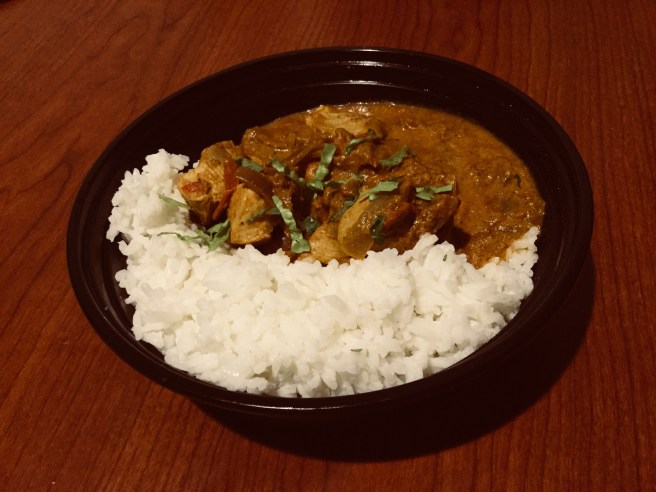
Alfred Systems: Personal Research
I decided to research the infrastructure systems in Alfred. I define infrastructure as the public framework that supports a city.
My prompts are:
– Document what infrastructure I use to travel around Alfred, and incorporate it into a visual representation.
– Collect water samples from infrastructure in Alfred.
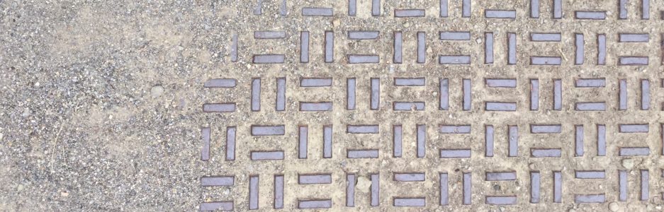
To document the infrastructure I use on a daily basis I took pictures of all of the different types of sidewalks and stairs I used while on a walk around town. My pictures are in the slideshow below:
To incorporate these into a visual I created a foot template and cut out concentric shapes from each of the photographs. I combined these to make a footprints that each have a piece of a different sidewalk, road, or stair in them. My process is displayed below:


To explore unseen infrastructure I collected various water samples that interact with public infrastructure in the Village of Alfred. I collected water samples from our suite, one from the bathrooms at Powell Campus Center, and from the places shown below:

Pothole behind Moskowitz

Canacadea Creek

Pothole behind Community Bank
Reflection: I had a lot of trouble coming up with ideas of what to research for infrastructure. I was washing dishes when I thought of collecting water samples from the pipes, roads, and waterways of Alfred. While I was walking around looking for easily accessible, visually interesting water. I noticed the different patterns on the various walkways I was travelling on. I particularly liked the coloration on the weathered metal staircases around campus. I started taking pictures of what I was walking on and thinking about how to incorporate it into a clear visual representation. I found that the best ideas came out of doing something, rather than sitting around thinking about what to do.
Home Systems
Alfred Group Map
In class on Monday we went out individually and explored and photographed parts of Alfred that we had never seen before. When we returned, as a class we were tasked with creating a map of the village and its limits. We were partnered up and recreated the space between the two locations we explored. I walked along Canacadea Creek and my partner, Mary, walked further north west past the tennis courts. I noticed on our walk that the elevation changed in very interesting ways, I really wanted to incorporate that into our representation of the area. I started by making a cardboard frame that showed Canacadea Creek submerged and McLane elevated from the other features around us.

In addition to the topography, one of the most noticeable aspects of our journey was the bright green of the vegetation around us. We decided to incorporate this into our design as the main source of color. I found it quite hard to represent the creek in a natural way that wouldn’t take away from the color of the grass. When I was brainstorming ideas for representing the creek I had this idea of incorporating water into the installation. I wasn’t sure how i was going to accomplish this but it was in the back of my mind as I was laying down grass and rocks. Then I reached for my bag to get some materials and I saw a near empty plastic water bottle tucked in the bottom. I took it out sliced it in half lengthwise and filled it with pebbles and water. I placed it neatly in the little valley I created, and it became Canacadea Creek.


I walked in on Tuesday morning and was a bit surprised. There was a lot of open space that wasn’t filled in at all. This may have been because people partnered up with those closest to them, but from looking at the map, this clearly wasn’t the case for all groups. I think another cause of the white space was unclear borders. My partner and I communicated closely with one of the groups next to us, but didn’t really interact with any other group in our proximity. If this was the case with the other partnerships than it is very understandable why there was space left unfilled.
I also found the inaccuracies in the map intriguing and frustrating. There were not only places in locations where there shouldn’t have been, but also multiples of different key landmarks. This was definitely due to miscommunication at the beginning of the activity. People may have thought the map was oriented in a different way, or maybe weren’t sure of where exactly they were. I think if there was a way to fix this it would be to have a printed or projected a map of Alfred where everyone marked the path they traveled and then determined who their surrounding group members would be. Overall, I think this was an interesting project with an unexpected outcome, and I was very impressed with everyone’s different ways of representing the space.