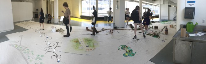
In class on Monday we went out individually and explored and photographed parts of Alfred that we had never seen before. When we returned, as a class we were tasked with creating a map of the village and its limits. We were partnered up and recreated the space between the two locations we explored. I walked along Canacadea Creek and my partner, Mary, walked further north west past the tennis courts. I noticed on our walk that the elevation changed in very interesting ways, I really wanted to incorporate that into our representation of the area. I started by making a cardboard frame that showed Canacadea Creek submerged and McLane elevated from the other features around us.

In addition to the topography, one of the most noticeable aspects of our journey was the bright green of the vegetation around us. We decided to incorporate this into our design as the main source of color. I found it quite hard to represent the creek in a natural way that wouldn’t take away from the color of the grass. When I was brainstorming ideas for representing the creek I had this idea of incorporating water into the installation. I wasn’t sure how i was going to accomplish this but it was in the back of my mind as I was laying down grass and rocks. Then I reached for my bag to get some materials and I saw a near empty plastic water bottle tucked in the bottom. I took it out sliced it in half lengthwise and filled it with pebbles and water. I placed it neatly in the little valley I created, and it became Canacadea Creek.


I walked in on Tuesday morning and was a bit surprised. There was a lot of open space that wasn’t filled in at all. This may have been because people partnered up with those closest to them, but from looking at the map, this clearly wasn’t the case for all groups. I think another cause of the white space was unclear borders. My partner and I communicated closely with one of the groups next to us, but didn’t really interact with any other group in our proximity. If this was the case with the other partnerships than it is very understandable why there was space left unfilled.
I also found the inaccuracies in the map intriguing and frustrating. There were not only places in locations where there shouldn’t have been, but also multiples of different key landmarks. This was definitely due to miscommunication at the beginning of the activity. People may have thought the map was oriented in a different way, or maybe weren’t sure of where exactly they were. I think if there was a way to fix this it would be to have a printed or projected a map of Alfred where everyone marked the path they traveled and then determined who their surrounding group members would be. Overall, I think this was an interesting project with an unexpected outcome, and I was very impressed with everyone’s different ways of representing the space.